Click to Download the PDF
Download the Word Doc
President’s Message
Welcome to the October Newsletter of the Georgina Historical Society! A thank you to all the members who have renewed their membership in the Georgina Historical Society during the past year, your support is very much appreciated.
We are hoping to hold our 2021 Annual Meeting on November 18 in the evening. The venue and further details of the meeting will be sent out after our Board Meeting on November 1. I look forward to seeing you at our Annual Meeting. We certainly have missed holding our regular events and activities but things seem to be looking better for 2022 with the latest announcement on the Covid situation and the easing of restrictions.
Thank you for taking time on September 30, National Day for Truth and Reconciliation to reflect, recognize and commemorate the legacy of residential schools. Special flags were raised at the Civic Centre and at Jacksons Point and an Eastern White Cedar was planted at the Link. I would like to especially mention the summer long special tribute at Black River Road and Park Road, a very well done and maintained tribute to the residential school legacy. We must remember the past in order to change the future! November 11 will soon be here, please remember to wear your poppy, support your local legion and take time to honor our veterans and all those who gave their lives in service of their country.
Take care, stay safe.
~ Tom Glover
Travelling Early Roads ~ by R. W. Holden
Early travel was a difficult proposition; roads as we know them were virtually non-existent. The early explorers and native peoples followed old trails and waterways through a primeval wilderness that knew almost no towns and villages. Only a few scattered settlements existed, occupied mainly by natives and a few Christian missionaries. The earliest travellers often followed these same routes as they arrived at first to explore and then to settle upon the land.
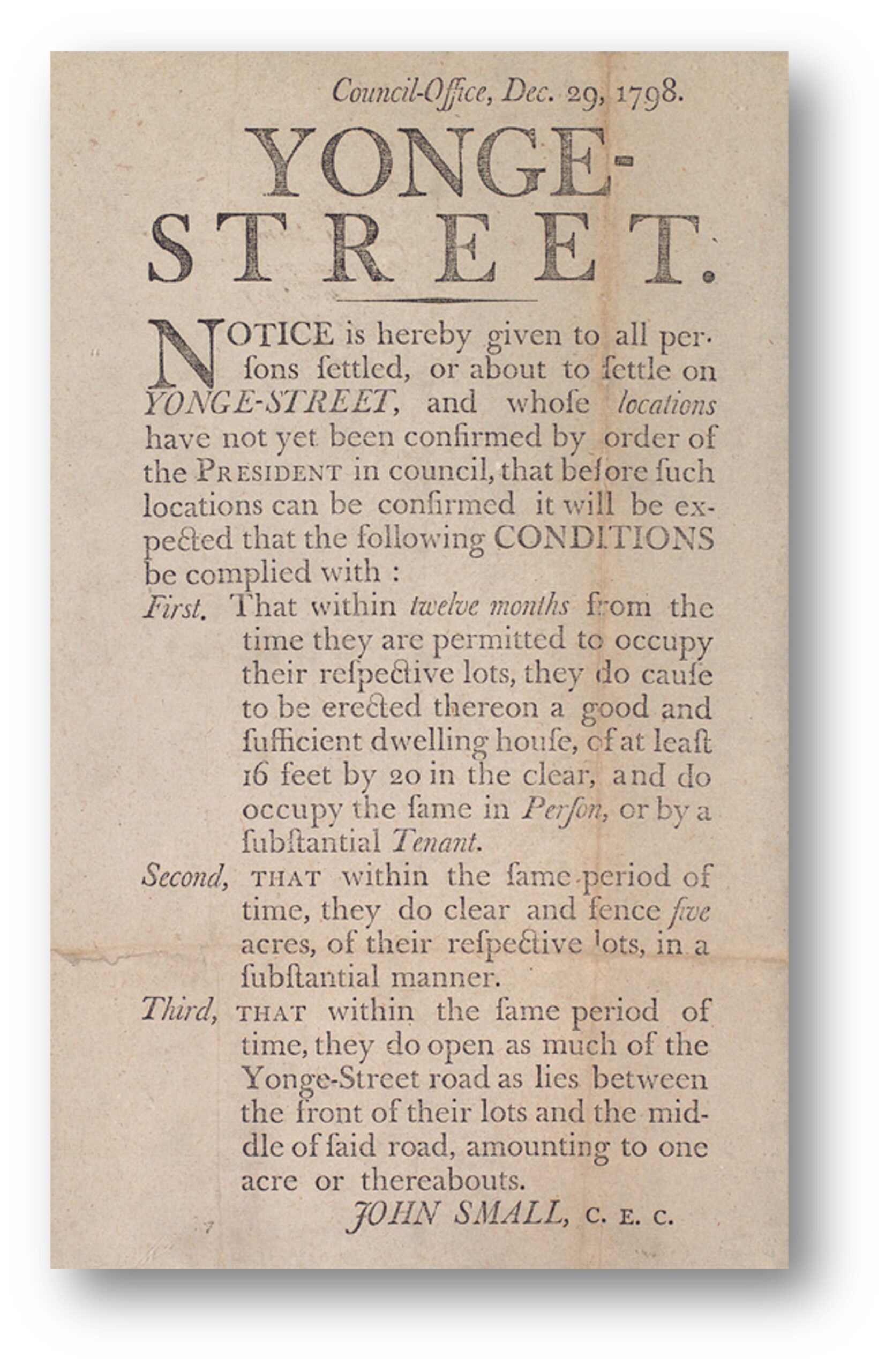
In addition one out of every seven lots in early Upper Canada was set aside as a Clergy or Crown Reserve and left vacant. There were also a large number of lots, especially in back townships with absentee owners. So unlike along main roads such as Yonge Street, the Dundas Highway, or Danforth Road, road allowances were inconsistent and poorly developed. Besides, the former were surveyed, developed and built as key transportation routes without always waiting for settlement duties to be completed. The latter were often not much more than blazed trails.
Among the earliest roads to link the townships of Georgina and North Gwillimbury to the communities to the south was the Catering Road leading to the southwest from Sutton through Ravenshoe to Queensville and Newmarket. Far shorter and more direct than the surveyed road allowances, it provided a better route for settlers coming to take up land and a reasonably direct way for them to get their produce to market. Another early road led north from Newmarket through Sharon and Queensville to the hamlet of Medina, now called Keswick. From there, one could continue north past Old Homestead Road, then west to Keswick (today’s Roches Point), or at Old Homestead Road, go east to Belhaven, and then further via Country Mile Road to the Catering Road and Sutton. Farmers in the Sutton and Pefferlaw area often travelled south through Uxbridge to the grain market at Manchester, or onwards to the docks of Whitby and Oshawa with their produce.
In 1906 John Claughton spoke of “farmers from Georgina, Brock, Uxbridge, and Scott all teamed their wheat to Whitby or Oshawa. When this traffic was at its height there would be a string of teams stretching as far as the eye could reach and all moving south. It was almost impossible to drive north then because of the traffic moving in the opposite direction. That was when the old plank road extended from Manchester to Whitby.
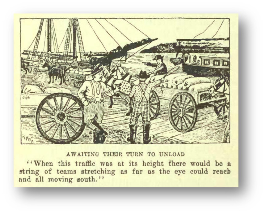
Much of the plank for that road was cut in the Paxton mill at Port Perry. There were five toll gates on the highway, and the toll for the round trip was three York shillings. [A York shilling, equivalent to twelve and one half cents, was a common unit of calculation in early days.] The wheat taken over it to Whitby was shipped to Oswego and thence to England. The wheat taken to Oshawa was ground in the Gibb’s mill.” (1)
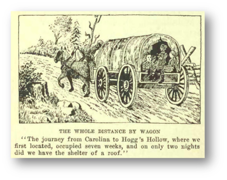
Mr. McFadyen tells of his ancestors settling in Upper Canada, “The party finally reached Hogg’s Hollow and settled there for a year. Then they set out for their permanent home in the township of Eldon. This was the worst of the whole journey. Once, when they struck a cedar swamp, the wagons sank to the axles and a whole day was spent in going four miles. The Horses were barely able to pull the wagons through the slime, and the men had to carry the luggage on their shoulders. The wagons could not be taken beyond Uxbridge, the rest of the way to lot seven on the first of Eldon being a blazed trail. All told, five days were spent in making a journey that an automobile would cover now in less than two hours of a summer afternoon.”(2)
Initially, people mostly walked and carried their burdens on their backs; the poorest of settlers usually lacked draught animals. One description came from a Mr. McFadyen, “Some of neighbours were worse off than ourselves. One man, with nine children, was forced to carry all the grain he used that first winter to Newmarket on his back, and to carry the flour back in the same way. He was kept going and coming all winter, because no sooner had he carried in one load of flour than he had to start back for another.”(3) Those that could afford it went on horseback or used two-wheeled ox-carts. Most roads were so poor that wagons could only be used with the greatest difficulty and they often lacked axle clearances over stumps and proper bridges across water courses.
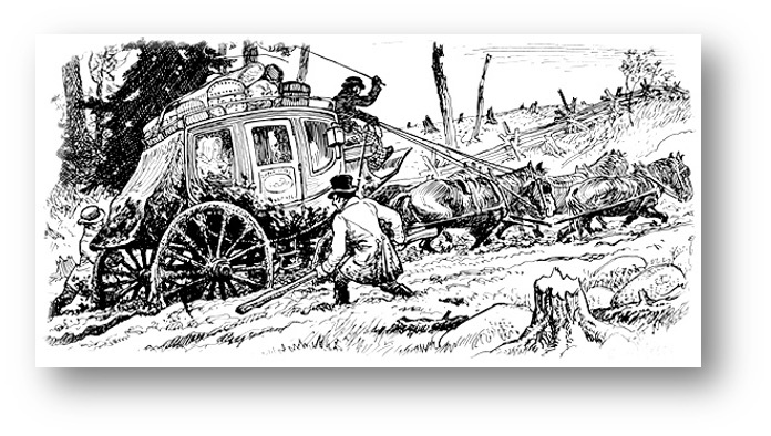
Since the technology of road-making had not yet arrived into the backwoods, they were hard and rutted clay in dry weather or a mire of mud when it was wet. In rainy weather it would not be unusual to see male passengers of a stage coach utilizing fence rails to pry out their conveyance mired in mud up to the axles!
By the 1830’s, the first macadamized roads were constructed with a proper substrate of gravel and ditching to drain away surplus moisture. Macadamization was invented in Britain by Scottish engineer John Loudon McAdam around 1820, in which single-sized crushed stone layers of small angular stones are placed in shallow lifts and compacted thoroughly. A binding layer of stone dust (crushed stone from the original material) may form; it may also, after rolling, be covered with a binder to keep dust and stones together. The method simplified what had been considered state of the art at that point. In Upper Canada, it was to pave by laying and compacting successive layers of broken stone, and crushed gravel sometimes with a top layer of asphalt or hot tar, though the latter was only seen in the largest communities and only on the most important roads almost until the twentieth century. Roads began to improve slowly, but only on major thoroughfares. Paving was unknown. As late as the first decade of the twentieth century, images of horse-drawn wagons may be found mired to their axles in mud. The only alternative to inland travel was to be situated on a major water route using sails, oars or paddles, though some ferries were powered by treadmills using horsepower.
Winter and the dry hot days of summer were the best times to travel. Then the roads would be hard-packed earth or frozen. In winter, you didn’t need to always follow the roads except in forested areas; it was possible to slide across open fields in a sleigh. The ride was quicker and much smoother. Spring was the worst for travel. As the snow melted and the frost came out of the ground, the roads would heave; soft mud entrapped the narrow wheels of carts, wagon, and carriages ensuring a long uncomfortable journey which should be avoided as much as possible. Corduroy roads of logs over swampy land would heave often causing broken axles and wheels.
Public transportation soon followed once a half suitable road was put into place. One of the earliest was developed by George Playter along Yonge Street. Teamster and stages would soon ply their trade on major roadways, but that is a story for another article!
1. https://www.electriccanadian.com/history/ontario/ontario/ontario5.htm
2. https://www.electriccanadian.com/history/ontario/ontario/ontario5.htm
3. https://www.electriccanadian.com/history/ontario/ontario/ontario5.htm\
4. Image one: https://commons.wikimedia.org/wiki/File:Notice_to_settlers_on_Yonge_Street_1798.jpg
5. Image two and three: https://www.electriccanadian.com/history/ontario/ontario/ontario5.htm
6. Image four: https://www.dalzielbarn.com/pages/TheFarm/ComeToCanada.html
Also consulted: The Story of Canadian Roads, E.C. Guillet, University of Toronto Press 1967
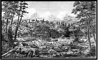
Georgina in 1885
The following passage has been excerpted from The History of the County of York, Volume 1, C. Blackett Robinson Publisher 1885 pp. 161-163. It paints an interesting picture of the Township of Georgina as it existed in 1885. Your editor has made some minor edits in the punctuation and syntax to improve the way it reads. Next month we will have a look at North Gwillimbury from the same source.
“The two earliest settlers in Georgina, so far as known, were Captain James O Brien Bouchier and John Comer. The former commanded Fort Penetanguishene during the war of 1812, and afterwards took up land like many other officers who retired on half-pay at the close of hostilities and became permanent settlers. The first white child born in the township was the daughter of John Comer, who lived to a good old age. Mr. Comer was the first assessor and collector of the municipality. Georgina was united for municipal purposes with the adjoining Township of North Gwillimbury until 1826. After the separation took place, the first town clerk elected was Alexander Craig Lawson, the first, and for some time the only, school teacher in the township, who held the clerkship for many years. The accessible records of the township are very scanty, and but little information is procurable as to the early officials. The first reeve was Charles H. Howard, who held office during the years 1850-51. The position was filled in 1852 by James Bouchier, in 1853 by John Boyd, in 1854-55 by Samuel Park, in 1856 by W. S. Turner. Angus Ego, the present township clerk, succeeded him, and continued in office for the six years 1857-62, and after an interval of one year, during which Archibald Riddell filled the chair, was again chosen for 1864-65. Then Archibald Riddell had a six years term, and was followed by Donald McDonald, who presided over the council for five years consecutively. James Anderson was chosen in 1877, and re-elected in 1878. Mr. Ego was township clerk and treasurer from 1872 until 1877, when John Guben was chosen clerk and George Evans, junior, treasurer. In 1878 P. McPherson was clerk. Angus Ego was re-elected township clerk in 1881. The officials for 1884 are as follows: Reeve, J. R. Steven son, Georgina ; deputy-reeve, Henry Park, Vachill; councillors, John Kay, Mark Kay and Christopher Raynard; treasurer, George Evans, junior; collector, George Lake; assessor, Wm. E. Tomlinson; auditors, Alexander Williams and William Fry.”
“In 1842 Georgina contained 586 inhabitants. The population in 1850 had increased to 946. In 1871 the number was 1,987. While most of the townships of this county have decreased in population during the decade1871-81, Georgina shows an increase of about one-fifth, the number of inhabitants, according to the last census; being 2,482. Of these 2,039 are native Canadians. The occupiers of land number 298; occupants, who are also proprietors, are 216 in number. The total area in occupation is 29,469 acres, of which 16,938 acres are improved. The portion of this under tillage is 13,109 acres, 3,514 acres being grazing lands, and 315 acres in gardens and orchards. The returns of agricultural produce for 1849 gave the following figures in round numbers: 13,000 bushels of wheat, 8.000 bushels of oats, 3,000 bushels of peas, 9,000 bushels of potatoes, and 9,000 bushels of turnips. The Dominion census of 1881 gives the following as the yield of the staple crops: Wheat, 39,467 bushels; barley, 13,769 bushels; oats, 70,261 bushels; peas and beans, 22,426 bushels; potatoes, 25,304 bushels; turnips, 78,583 bushels, and hay 2,196 tons. As closely as can be ascertained, the acreage of agricultural land is distributed among the leading crops in the following proportions: Fall wheat, 10 per cent.; spring wheat, 20 per cent.; barley, 5 per cent.; oats, 8 per cent.; peas, 6 per cent.; potatoes, i per cent.; turnips, 2 per cent; hay 10 per cent.; pasturage, 30 per cent.; orchard, i per cent. The land yet uncleared, about one-third of the total area, is timbered with hemlock, hardwood, cedar and tamarack. The live stock of the township in 1881 included 1,684 head of cattle, 823 horses, 1,485 sheep and 606 hogs. The varieties most extensively raised are heavy draught horses and ordinary cattle. The quantity of thoroughbred stock raised in the township is small, but increasing. Among those who are owners of Durham cattle may be mentioned John L. Howard and James Baine.”
“Sutton, also known as Georgina, the latter being the name of the post office, is the principal village in the township. It was originally called Bouchier’s Mills, and owes its origin to the enterprise of Captain James O Brien Bouchier before referred to, who established a flouring mill and factories, and did a great deal in other ways to build up the village as a centre of population. Sutton is located on the Black River, about three miles from Lake Simcoe, and on the western boundary of the township. It has about 700 inhabitants, and is in a flourishing condition. The Church of England and Presbyterian bodies have places of worship here. Smith, the author of Canada : Past, Present arid Future, states that in 1851 Sutton contained a grist and saw mill, a carding and fulling mill, a tannery, and a new cloth factory in course of erection. Of these only the saw and flouring mill are now in operation, and no new industries have taken their place. The tendency of our modern manufacturing system is all in the direction of centralization in the larger towns and cities, and the smaller factories which used to build up the country villages are becoming either abandoned or transferred to the great industrial centres.”
“Jackson s Point, which lies about a mile and a half to the north of Sutton, a picturesquely wooded headland, is the terminus of the Lake Simcoe Junction Railway. It is a favourite resort for excursion parties, and in addition to the beauties of the scenery it has the attraction of boating and fishing, and there are frequent steamboat trips to Belle Ewart, distant about ten miles, and to other points on the lake. The other villages are Port Bolster, situated, as its name indicates, on the lake, at the extreme north eastern angle of the township; Virginia, about midway between this point and Sutton, a mile or so distant from Lake Simcoe; Pefferlaw, in the eastern portion of the township, about three miles south-west of Port Bolster, and Vachell and Baldwin, in the western part of the township. In the south-eastern corner of the township there are three small lakes connecting with the stream which reaches Lake Simcoe near Port Bolster, and there is also another near Pefferlaw.”
“Georgina contains six sections, with seven Public schools;”
“No. 1, a union with North Gwillimbury, is situated in the Village of Sutton, the terminus of the Lake Simcoe Branch of the Midland Railway, now a part of the Grand Trunk system. The building is a handsome and substantial brick structure, with rooms for three teachers. The Principal is Robert Sanderson, whose well-directed labours have secured for his pupils several third and intermediate certificates, as well as a large number for entrance to High Schools. The average attendance is about 120.”
“No. 2 is situated on the line running east from Sutton, at about four miles distance, on the south-east corner of the farm of George Evans, Esq., the township treasurer. It is a large frame house, and the average attendance is about 44. Miss S. Tomlinson is the teacher.”
“No. 3, the school of the fertile and attractive district known as Egypt, is situated about two miles east of the Baldwin station of the Lake Simcoe Railway, and about four south-east of Sutton. It is a large frame house, with rooms for two teachers, of whom the present headmaster is George A. Cole. For years this school has held a foremost place for efficiency. The average attendance is about 56. The assistant is Saidie Cameron.”
“No. 4, called the Pefferlaw School, stands about half a mile south of the Black River Bridge, on the same line as No. 2, and about seven miles from Sutton. It is a mile north of the Village of Pefferlaw. It is a new and good frame structure. The average attendance is 47. Thomas A. Wilson is the present teacher.”
“No. 5, the Udora School, is situated three-quarters of a mile north of Udora, on the base-line, and in the south-east corner of the township. The house is a new and comfortable frame building. The average attendance is about 30, and the teacher is Miss Maggie Thomas.”
“Sub-section No. 5 is a division of No. 5, with a new frame house, about two miles to the west of No. 5. At present it is only kept open for six months of the year, but when paid for, and the liberal sentiments of the whole section are a little more developed, the children of the western part of the section will be as well provided for as those of the eastern. Miss Orphea Birdsall was employed during the first half of 1884.”
“No. 6, or Cedarvale School, is situated on the base-line, a mile and three-quarters south of the Egypt School, from which it is a recent offshoot. The house is a new and substantial frame building. The teacher, Miss Bertha Appleton, has an average attendance of 36.”
Where in Georgina?
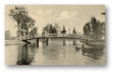
No-one has guessed our June mystery location so we will reserve it for another time. Above is our September mystery location.
We’ll try again; where in Georgina was the image located?
Early Pioneers
The Elmgrove School ~ by Tom Glover
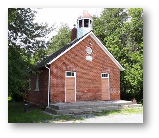
The photo featured on the Georgina 2021 calendar for the month of October is the Elmgrove School House.
The Elmgrove School house, built in 1881 is a perfect example of the elementary schools of the last century and one of the few one room schools in York Region that still remain under municipal ownership. Situated at the intersection of Homestead Road and the Catering Road it served the community for generations as not only the centre for education but the hub of the community. When it ceased to function of as an elementary school, the building was used as a day care centre and as a community gathering place. Unfortunately, due to structural concerns it has sat unused and neglected for a number of years. It would be great to see this building once again serve residents of the community.
News
Our caboose is shaping up! There is an old stove in storage that will be suitable for the caboose that we will be adding a table asnd a bench for sleeping as interior furnishings on one side of the caboose. Normally two additional benches would have been located on the other side but that space will be used for displays telling about the history of cabooses and our caboose in particular.
Owing to recent resignations, we have vacancies on our Board. If you know of a interested member that might be willing to stand for election please contact Tom Glover so their name can be put forward for the elections at the AGM in November.
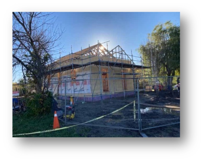
Kudos to the Town of Georgina! Below we can see the progress made to date with the rebuild of Cedarbrae School in the Pioneer Village. The image below left is a view from the rear of the building and the one on the right shows the front. Miss Bertha Appleton would be proud to see this were she still around! (See the note about school #6 in the Georgina article.

Events
November 1, 2021 – 2:00 PM Board meeting venue to be advised.
November 18, 2021 – Annual General Meeting; time and venue will be sent out after the November 1 Board Meeting.
Note: COVID restrictions are unfortunately still in place; any changes to that will be advised as soon as possible to the membership.
